Field Reports · 2022 – 2025

Field Report
2022–2025

Season-by-season accounts and commissioned scientific assessments — documenting real progress, real setbacks, and real science from ECOREWIRE's restoration operations and biodiversity fieldwork across Edo State, Nigeria.

2
Published field reports
20 ha
Udakpa actively restored
464 ha
Iguobazuwa CA surveyed
133
Species recorded
Report Series 01 · Udakpa Pilot Site
2022–2024 Archive
Location
Udakpa, Ubiaja · Esan South East LGA · Edo State
Period
2022 – 2025
Site Area
51 ha · 20 ha actively restored
Lead
Prof. E. M. Isikhuemen
Systematic documentation of ecological recovery

A documented account — with correct field photographs — of planting operations, wildfire crisis and recovery, fire-tracing, nursery propagation, agroforestry development, and monitoring activities at ECOREWIRE's permanent 51-hectare ecosystem restoration pilot site. All photographs sourced directly from named field image files and verified against site logs.
2022 · Field Operations & Agroforestry
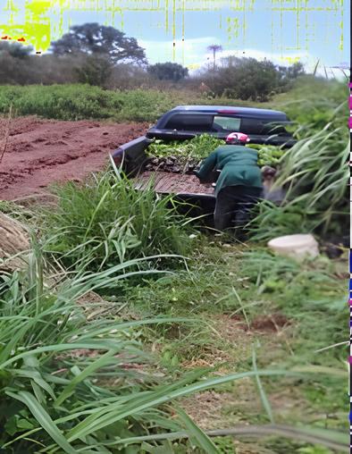
Seedling transport operation at Udakpa Field Operation
01
Transporting seedlings to Ecorewire Centre Project site — 2022
R1 · Entry 01 · 2022
Nursery to Field · Planting Season
Seedling transport from Aduwawa nursery to Udakpa (2022)
Seedling logistics and handling protocols
This photograph shows the field transport operation at the ECOREWIRE Centre Project site in 2022 — a team member loading freshly nursed seedlings from the Aduwawa nursery in Benin City for transport to the Udakpa project site. By 2022, approximately 5 hectares had already been planted with assorted endangered and vulnerable endemic rainforest timber tree species. Each consignment required careful handling during the journey from nursery to field to prevent root ball damage or desiccation. Additional seedlings beyond those planted at Udakpa were distributed to individuals and organisations to stimulate community and private sector involvement in rehabilitation of declining timber tree species.
Seedling transportField operations2022 planting season
2022
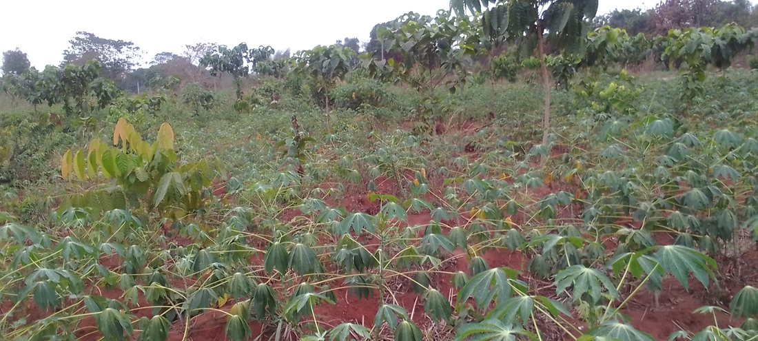
Cassava interplanted with forest tree seedlings 2022 Agroforestry Model
02
Cassava interplanted with forest tree seedlings at Ecorewire Centre Project Site (2022)
R1 · Entry 02 · 2022
Agroforestry · Inclusive Restoration
Cassava interplanted with indigenous timber seedlings — inclusive agroforestry in practice
Ecorewire Centre Project Site, Udakpa · 2022
Young indigenous timber tree seedlings deliberately established alongside cassava crops — illustrating the early phase of ECOREWIRE's inclusive agroforestry model. Subsistence farmers cultivate food crops between tree rows, sustaining household livelihoods while the tree canopy develops. The cassava provides initial shelter for vulnerable young seedlings, reducing soil temperature and moisture stress during establishment. As trees grow and their canopy closes, the cassava is progressively phased out as the forest structure becomes self-sustaining — a deliberate, community-sensitive transition that removes the economic incentive for land clearance.
Cassava intercroppingAgroforestryInclusive FLR
2022
2022 – 2023 · Wildfire Crisis & Response
Field Report · Crisis & Resilience
Wildfire strikes — 10 hectares burnt and systematically replanted
During the last quarter (dry season) of 2022 through early 2023, two wildfire incidents occurred at the Udakpa pilot site, destroying most young poles and saplings across approximately 10 hectares. Fires spread from adjacent farmland where slash-and-burn clearing is still widely practised. ECOREWIRE responded immediately: during the 2023 planting season (June to August), the burnt portion was systematically replanted. Beating-up was carried out in other fire-affected areas, and surviving stumps and root crowns with viable coppice regrowth were retained and incorporated into the replanting plan. The experience directly shaped ECOREWIRE's subsequent fire-tracing programme.
2023 · Fire-Tracing — Two Correct Separate Photographs
Field Operations · Fire Prevention
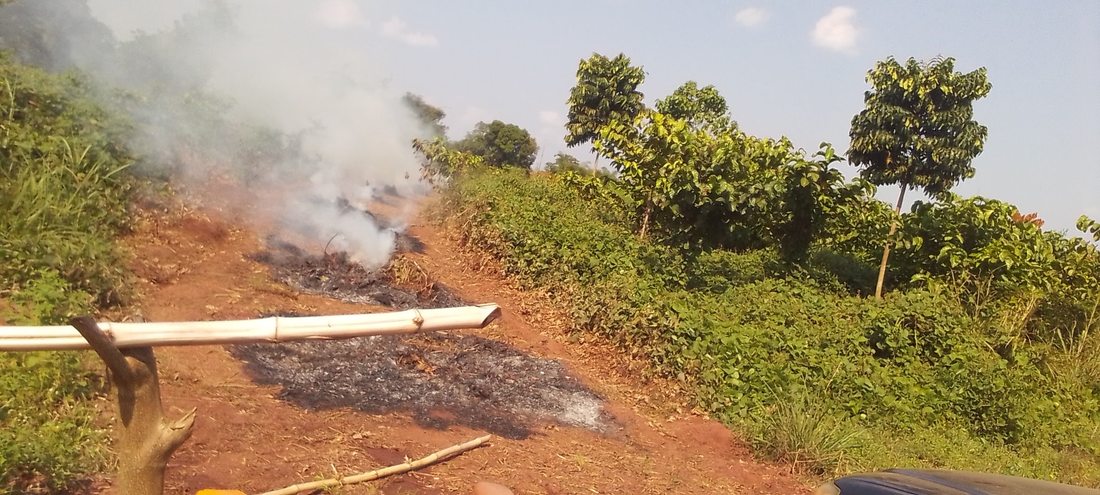
Fire-trace tracks established — both photographs now correctly sourced from named field files
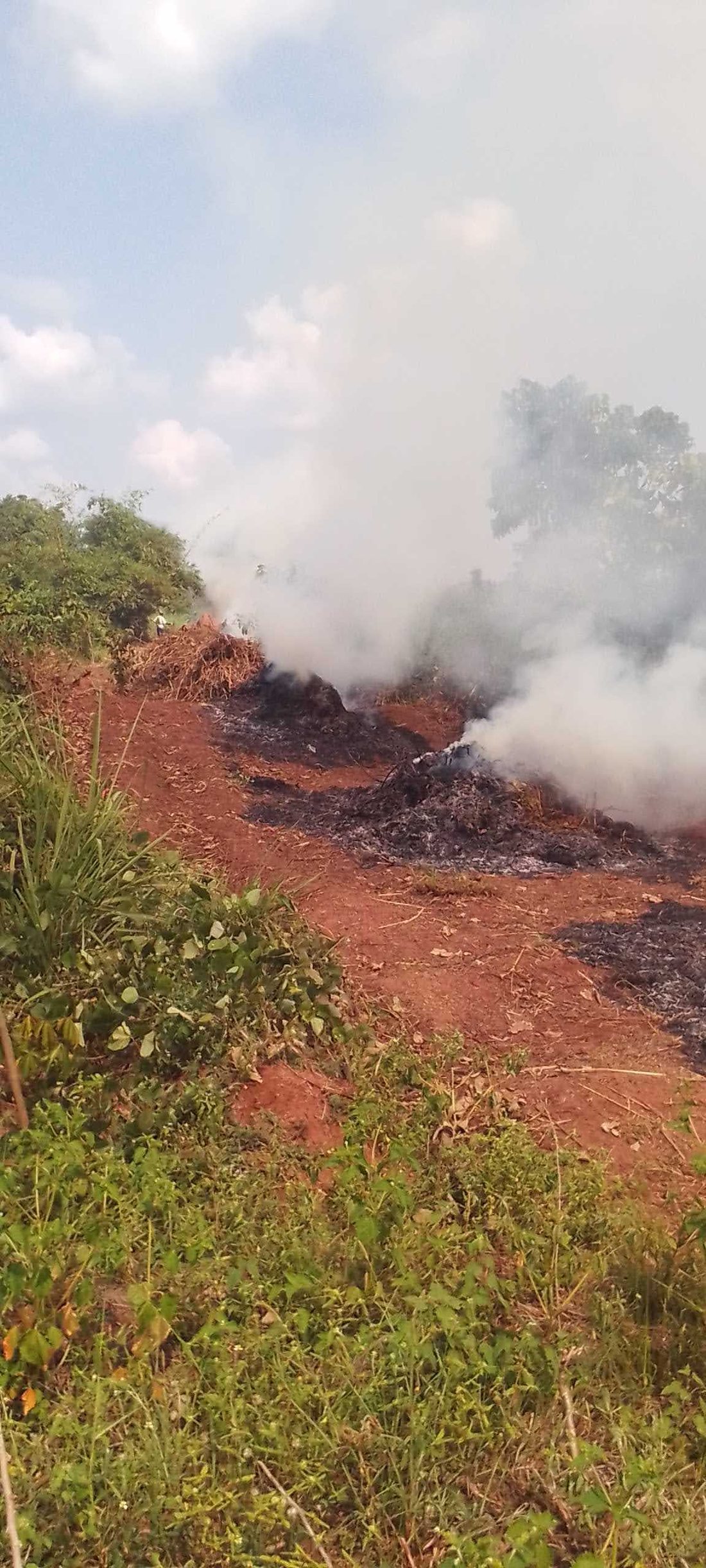
During the last quarter of 2023 and early 2024, fire-tracing was carried out at strategic but vulnerable locations at the Udakpa pilot site. Fire-tracing involves the systematic clearing and maintenance of firebreak corridors — strips of cleared, low-fuel ground that block the lateral spread of fires from neighbouring farmland. The two photographs below are now correctly sourced from their individual named image files — no longer merged composites — each showing a distinct fire-trace operation at the site. The programme proved effective: the 2024 dry season passed without any repeat wildfire incidents.
Fire-trace track 2022/2023
Fire-trace track in Ecorewire Centre (2022/2023) — controlled burning along the firebreak corridor clearing accumulated dry fuel load from the perimeter zone
Fire-trace track 2023
Fire Trace Track in Ecorewire Centre Project Site (2023) — second strategic firebreak track with smoke visible from the clearing operation at a vulnerable internal zone
2024 · Nursery, Agroforestry & Milestones
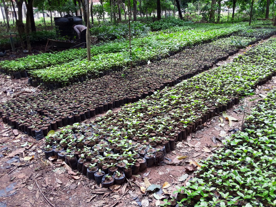
Aduwawa Nursery 2024 Nursery 2024
03
Ecorewire nursery at Aduwawa, Benin City (2024)
R1 · Entry 03 · Nursery 2024
Nursery Operations · Post-Fire Recovery Stock
Aduwawa nursery — 50,000 seedlings raised including post-fire replacement stock
Ecorewire Nursery, Aduwawa, Benin City · 2024
In 2024, nursery attention at Aduwawa was focused on raising Nauclea diderrichii and Khaya spp. specifically for refinement and beating-up of the burnt portions at the Udakpa pilot site. This photograph shows the scale of the 2024 nursery production — thousands of potted seedlings in production rows, representing 50,000 assorted indigenous species raised across the full cycle. The nursery functions as both the supply base for external client contracts and as a living gene bank for Edo State's native forest flora, with seedlings matched to specific ecological conditions of each destination site before dispatch.
50,000 seedlingsPost-fire stockNauclea · KhayaAduwawa
2024
Field Evidence · 2024 — Agroforestry maturity & Rehabilitation milestone
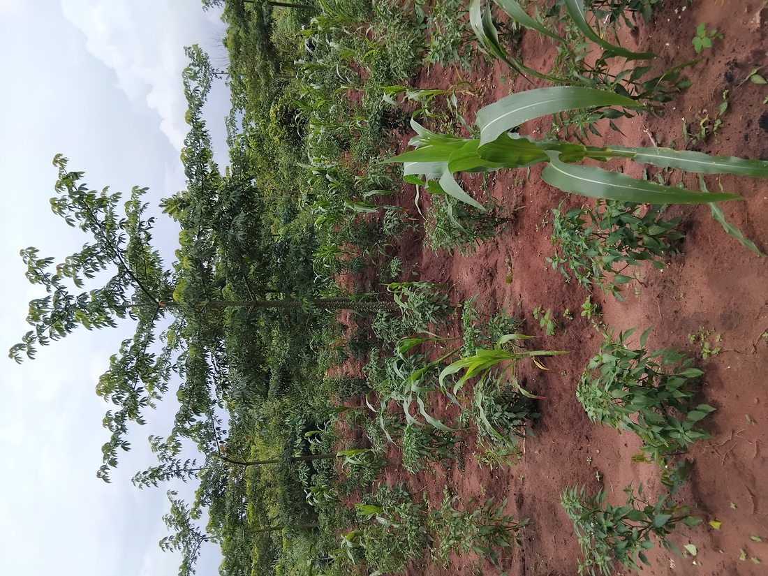
2024: agroforestry maturity and canopy closure achieved
By 2024, two landmark developments were visible at the Udakpa pilot site. Left: the forest tree and arable crop mixture in 2024 shows a mature multi-storey agroforestry system — maize growing alongside established indigenous timber tree saplings, demonstrating the practical success of the 'double filter' approach. Right: the successfully rehabilitated portion — the section first planted in 2019/2020 has attained the initial stage of canopy closure by 2024, five years after planting commenced on bare degraded land. Captioned "Ecorewire Centre — successfully rehabilitated portion (2024)" in the original field documentation, this milestone demonstrates that the FLR methodology delivers measurable ecological recovery.
Agroforestry mixture 2024
Forest tree and arable crop mixture at Ecorewire Project Site (2024) — maize and other crops beneath an established multi-storey indigenous timber tree canopy
Successfully rehabilitated 2024
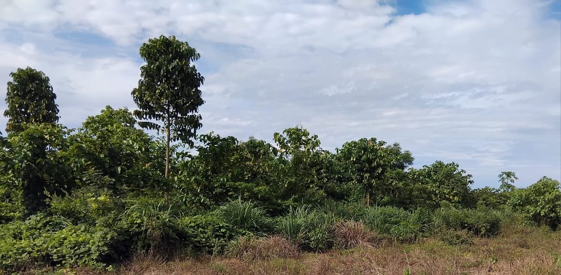
Ecorewire Centre — successfully rehabilitated portion (2024) — Nauclea diderrichii and Khaya spp. at initial canopy closure stage, five years after planting
2025 · Latest Field Evidence
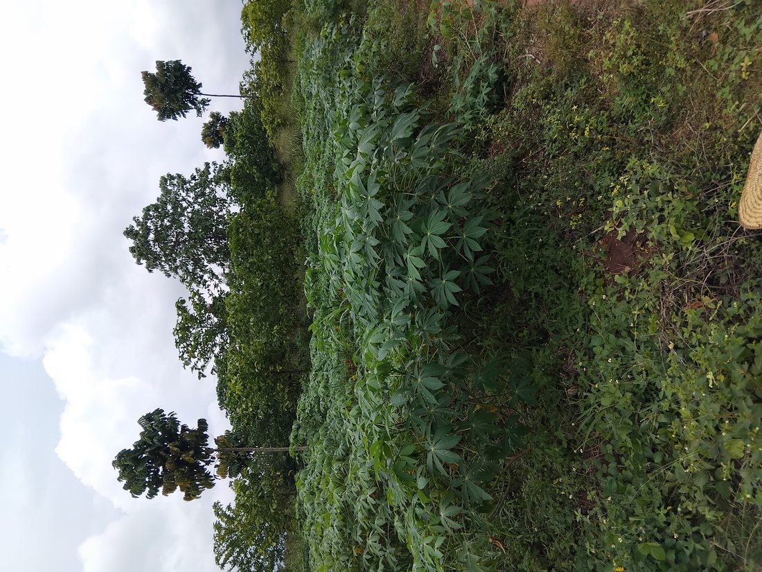
Cassava crop at frontal of restored forest 2025 Latest · 2025
04
Cassava crop at the frontal of restored forest at Ecorewire Centre Project Site (2025)
R1 · Entry 04 · 2025
2025 Field Evidence · Forest Frontal
Six years on — restored forest canopy stands behind active cassava cultivation
Ecorewire Centre Project Site, Udakpa · 2025
The most recent field photograph from the Udakpa pilot site (2025) shows cassava cultivation at the frontal margin of the established restored forest zone. The lush, densely canopied forest visible behind the cassava field represents six years of progressive FLR work. This single photograph encapsulates the essence of ECOREWIRE's approach: productive agricultural land use and ecological restoration existing side by side, with the forest steadily advancing as the restoration programme matures. The farming households cultivating the cassava at the forest margin are the same communities who participate in ECOREWIRE's agroforepreneurship programme — stewards who have both economic and personal stakes in the landscape's continued recovery.
Forest frontal 20256 years of FLRCommunity stewardship
2025
Report 02
Report 02 · Commissioned Scientific Assessment
Assessment of Biodiversity in RENL Conservation Area,
Iguobazuwa Forest Reserve, Edo State
Client
Rubber Estate Nigeria Limited (RENL)
Location
Osse River – Div 7, Iguobazuwa Forest Reserve · Ovia South West LGA · Edo State
Period
July – December 2025
Area
ca. 463.625 hectares
Contract
PCT/PUR/AGR/001/260625
A tripartite hands-on investigation consisting of baseline and impact segments — covering mega-flora and mega-fauna inventory, vegetation profiling, phenology, LULC mapping across five decadal epochs (1985–2025), carbon stock appraisal, and socio-economic profiling of two fringe communities. Output: the FERBRAP conservation and restoration action plan.
Acacia tangle infestation — RENL Conservation Area 2025 Iguobazuwa CA · 2025
01
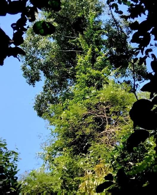
Acacia tangle infestation from forest floor to tree canopy — RENL Conservation Area, Iguobazuwa Forest Reserve (2025)
R2 · Assessment Overview
Commissioned Survey · IUCN Standards · NASA/USGS Landsat
464 ha Conservation Area — tripartite biodiversity and livelihood baseline assessment
Osse River Division 7, Iguobazuwa Forest Reserve · Lat. 6.53°–6.56°E / 5.96°–6.00°N
The CA was delineated into 45 randomly located 50m × 50m quadrats, 45 transects, and 10 subjectively sited 1m × 1m regeneration quadrats. Vegetation profiles were constructed in Plots 29 and 45 using 50m × 6m methodology. A Nikon Laser Rangefinder (Forestry 550) measured tree/shrub height; girth at breast height recorded at ≥30 cm threshold. Wildlife surveys used direct and indirect techniques — sightings, calls, faecal droppings, nesting sites, footprints, burrows — using Bushnell Binoculars (10 × 40). Shannon-Weiner diversity indices calculated. Four LULC maps covering 1985, 1995, 2005, 2015, and 2025 produced using NASA/USGS Landsat data and GIS. The cover photograph shows Acacia tangle infestation — one of the most severe ecological threats identified.
464 ha CA45 quadratsShannon-Weiner H'NASA/USGS LandsatAcacia infestation
July – December 2025
Key Findings · Flora, Fauna & Carbon
49
Plant families recorded
Fabaceae most abundant (23 spp.) · Rubiaceae 2nd (17 spp.)
133
Species recorded
High floristic diversity across 464 ha CA
2,953
Stems recorded
Across all 45 quadrats in the CA
H' 4.43
Shannon-Weiner diversity index
High diversity — all trees and shrubs
25–30 m
Average vegetation height
Mature closed-canopy rainforest structure
H' 2.578
Mammalian diversity index
Relatively low — poaching and anthropogenic pressure
6.5 m³/ha
Average timber volume
Severely reduced by illegal logging
0.55 tC-e/ha
Sequestered carbon equivalent
Above-ground biomass: 300.27 kg/ha
20%+
Trees with crown/bole damage
Caused by Acacia and liana infestation
IUCN Red List — Three Threatened Species Recorded
Okoubaka aubrevellei
Akpobisi
IUCN — Endangered
One of Africa's rarest timber species recorded within the RENL CA. Revered across West Africa for its spiritual and medicinal properties, critically threatened by habitat loss and selective extraction. Its presence signals significant biodiversity value in the CA.
Pausinystalia johimbe
Likiba / Yohimbe
IUCN — Endangered
Source of the internationally traded alkaloid yohimbine. Faces significant pressure from bark extraction and habitat destruction across its West and Central African range. Listed Endangered on the IUCN Red List.
Prioria balsamifera
Agba Gum
IUCN — Vulnerable
A large canopy timber tree valued for durable, fragrant wood. Experienced severe population decline due to commercial logging across Nigeria and West Africa. Classified as Vulnerable by the IUCN.
Anthropogenic Threats
🪵
Illegal Logging
Selective extraction of high-value timber contributes to the degraded timber volume of only 6.5 m³/ha. Over 20% of trees show debilitating crown or bole damage from Acacia or other lianas, compounding structural degradation from logging.
🌿
Acacia & Liana Infestation
Severe infestation from forest floor to canopy. The diagnostic study revealed inactive soil seed and seedling banks largely caused by climber tangle infestation, significantly impeding natural regeneration of key timber and keystone species.
🐾
Wildlife Poaching
Mammalian Shannon-Weiner index of only 2.578 reflects sustained poaching pressure. Direct and indirect survey techniques confirmed significantly reduced diversity relative to an intact Edo State forest reserve. A baby pangolin was found stranded in the CA in 2026.
🐄
Herder Encroachment
Browsing and trampling of vegetation by livestock herders within CA boundaries represents direct ongoing pressure on forest understory, ground layer regeneration, and soil structure.
🌾
NTFP Over-Exploitation
NTFPs including Megaphrynium macrostachyum, Aframomum spp., Enantia chloranta, and Thaumatococcus daniellii are intensively exploited by female-dominated fringe communities, providing critical livelihoods but undermining regeneration without management.
🛐
Sacred Groves
Two deities — Eziza and one unnamed — found inside the CA. These culturally significant sites must be sensitively incorporated into any conservation planning under the UNESCO MAB three-zone framework.
FERBRAP · Action Plan & UNESCO MAB Framework
Action Plan · UNESCO Man and Biosphere (MAB) Model
FERBRAP — Forest Ecosystem Restoration and Biodiversity Rehabilitation Action Plan
FERBRAP is designed to stimulate close-knit surveillance toward monitoring human activities, protecting biodiversity, and rehabilitating degraded portions of the CA using indigenous trees and shrubs on the IUCN Red List. It also aims at engaging a motivated security workforce with unrestrained access to training and modern monitoring equipment.

The recommended management model adopts the UNESCO Man and Biosphere (MAB) three-zone framework:
  • Core Zone — Strictly protected; no extractive activities permitted.
  • Buffer Zone — Activities compatible with sound ecological practices only; scientific research and monitoring.
  • Transition Zone — Regulated NTFP harvesting and sustainable agro-ecological enterprise for fringe communities.
Study Team · 11 Specialists
S/NNameExpertiseRole
1
Prof. Ekeoba M. Isikhuemen
Forest Ecology; BD Inventory; Diagnostics; NTFPs; Phenology; Terrestrial Carbon
Team Lead
2
Prof. Joseph S. Ogeh
Soil Fertility; Soil Carbon
Forest Soil Carbon
3
Prof. Henry A. Akinnibosun
Plant Ecology / Taxonomy
Herbs & Liana ID
4
Caesar O. Oviawe
Geodetic Survey; Land Use; GIS
LULC & GIS
5
Dr. Friday E. Osayimwen
Forest Ecology; BD Inventory; NTFPs; Phenology
Forest BD & Taxonomy
6
S. Okwa
Wildlife Inventory — Rainforest & Riparian
Wildlife Inventory
7
Felix Adamu Ovugie
Agricultural Extension & Rural Sociology
Socio-economics
8
G. O. Oyibotie
Forest Ecology; BD Inventory (Flora)
Instrument & Data
9
O. A. Imafidon
Forest BD Inventory
Field Assistant
10
Osaretin Odia
Forest BD Inventory (Flora & Wildlife)
Field Assistant
11
Friday I. Ewele
Taxonomy; NTFPs; Phenology
Field Assistant

Get in touch

Have a question or project? Send us a message and we'll respond quickly.